

Auto-Analyze reads each uploaded drawing against the checklist your municipality applies to that drawing type, reports what is present and what is missing, and, where the lot’s zoning is known, checks the drawn setbacks, height and coverage against the by-law. It is the plan check that used to happen only after submission, moved to before it.
How plan review gets done today
An examiner's first pass on a residential application is rarely about design judgement. It is a completeness and compliance check: does the site plan have a north arrow, a metric scale, the municipal address and the legal description? Are the setbacks dimensioned to the lot lines? Is the lot coverage stated? Does the height comply with the zone? Applicants find out how that pass went in the first comment letter, weeks after submission.
- The designer prepares the set to their own office standard, which may or may not match the municipality's drawing requirements page.
- The applicant checks zoning by reading the by-law, calling the zoning desk or ordering a zoning certificate, and interpreting a zone code such as "RD (f12.0; a370)" with its exceptions.
- The package is submitted and enters the queue.
- Weeks later, comments arrive: missing dimensions, missing site statistics, an elevation that does not show grade, a rear setback that appears short.
- The set is revised and resubmitted, often with the review clock effectively restarting, and the cycle repeats until the examiner is satisfied.
Each cycle costs the applicant weeks and costs the municipality a second full review of a set that could have been right the first time.
What the current process costs
| Failure mode | Consequence |
|---|---|
| Drawing missing a basic element (scale, north arrow, legal description) | Comment letter for an item that takes minutes to fix and weeks to turn around |
| Setback or height drawn outside the zone's limits | Discovered after submission; redesign, or a minor variance on a committee calendar rather than a review clock |
| Zone read incorrectly from the by-law map | Whole set drawn against the wrong standard |
| Different drawing standards in each municipality | Consultants maintain a checklist per city and still miss local items |
| Every comment cycle re-enters the queue | Review time compounds; construction start slips a season |
Arash Shahi's Residential Builder column makes the case that a centralized platform "would reduce back-and-forth between applicants and staff by validating applications upfront." That is precisely the gap: nothing in the current system validates a drawing set before an examiner spends time on it. The first reviewer of most Ontario permit drawings is the city, and the city is the most expensive reviewer available.
How Auto-Analyze works in Permits2Go
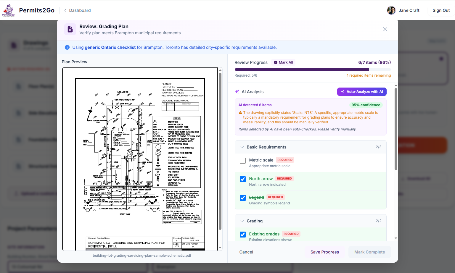
1. Upload a drawing to its card
Each required drawing on the application has its own card (see Form Discovery & Uploads). Upload the site plan to the site plan card, the front elevation to the front elevation card, and so on. The card knows what kind of drawing it is, so the review that follows is specific to that drawing type.
2. See the checklist the city will apply
Open the review panel and you see the checklist for that drawing in your municipality. For Toronto it is detailed: a site plan must show the metric scale, north arrow, municipal address, legal description with lot and registered plan numbers, all buildings and structures, setbacks to every lot line, overall dimensions and the site statistics table, among other items. Grading plans, floor plans, roof plans, elevations and pool fence site plans each have their own list. Municipalities without a published checklist of the same depth get a generic Ontario checklist, and the panel says so, so you know to confirm local specifics.
3. Run the review
The model reads the drawing and reports, item by item, what it found and what it could not find, with a confidence figure, notes on anything unusual and warnings where the drawing may not be legible enough to judge. The result is saved with the drawing, so the card shows the review status, and a drawing only counts as complete on the dashboard once it has been uploaded and reviewed.
4. Check the drawings against zoning
Enter the project address and Permits2Go looks up the lot's zoning from the municipality's official zoning map. Toronto, Oakville (both of its by-laws), Mississauga and Brampton are supported today, and any other municipality can be added by the Permits2Go team from its open zoning data. The lookup returns the zone code and name plus the requirements that apply to it: minimum setbacks, maximum height, maximum lot coverage, floor space index, minimum frontage and lot area, each with its by-law reference where available.
When the zone is known with certainty, the review of site plans, elevations, sections and grading plans also extracts the measurements that are actually drawn: front, side and rear setbacks, building height, lot coverage and floor area. Those numbers are then compared with the zone's requirements. Minimums must be met, maximums must not be exceeded, and a small tolerance absorbs drawing-scale noise. The result for each rule is pass, fail or unknown.
5. Fix it before the city sees it
Missing checklist items and any failed zoning rule are listed on the card. Send them to the designer, upload the revised sheet (the earlier version is kept) and re-run the review. The set that goes to the city has already been through the check the examiner will perform.
What you stay in control of
- The review reports; it does not decide. A missing item is a prompt to look, not a rejection.
- Zoning is never guessed. If the official map cannot place the address, the platform says the zone is unavailable rather than inventing one, and the compliance check is not run.
- Compliance results are shown as pass, fail or unknown, and a measurement that could not be read is reported as unknown rather than treated as a failure.
- Every by-law figure carries a note to verify with the municipality; the zoning summary is a starting point for the designer, not a substitute for a zoning certificate.
The workflow after
| Step | Before | With Auto-Analyze |
|---|---|---|
| First plan check | By the city, weeks after submission | On upload, minutes after the designer exports |
| Municipal drawing standards | Read from a web page, if published | Applied as a checklist per drawing type |
| Zoning | By-law map, zoning desk, interpretation | Official map lookup with the zone's requirements listed |
| Setback, height and coverage check | Examiner's scale rule | Measured from the drawing and compared before submission |
| Comment cycles | Two or three is normal | The first cycle addresses design questions, not missing basics |
The applicant still needs a competent designer, and the city still reviews every set. What changes is who finds the easy problems and when. Combined with Review Comment Responses for the comments that do arrive and Automated Reviewer Calls for the questions that need a human answer, the review phase stops being a black box that opens once a month.
Frequently asked questions
Does Auto-Analyze approve my drawings?
No. It reports which checklist items it found and which it could not, and compares drawn setbacks, height and coverage with the zone’s requirements when the zone is known. The municipality still performs the review that leads to a permit. Auto-Analyze exists so that review starts from a complete, compliant set.
Which municipalities have full drawing checklists and zoning lookups?
Toronto has detailed checklists for site plans, grading plans, floor plans, roof plans, elevations and pool fence site plans. Other municipalities use a generic Ontario checklist, and the panel tells you when that is the case. Zoning lookups cover Toronto, Oakville, Mississauga and Brampton today, and more municipalities can be added from their open zoning data.
What if the zoning lookup cannot find my address?
The platform reports that the zone is unavailable rather than guessing. You can still run the checklist review on every drawing; only the setback, height and coverage comparison waits until the zone is confirmed, for example from a zoning certificate you enter yourself.
This guide is general information, not legal or professional advice. Permit requirements, by-laws and fees change and vary by municipality — always confirm the current rules with your local building department before you design or build.
Industry figures cited above are from “Enough is Enough” by Arash Shahi, CEO of LandLogic, published in Residential Builder magazine.